Subdivision
and land surveysWhilst we are not a surveying company, we understand there are many survey requirements during the design and building process such as contour and building surveys, re-pegs and subdivisions. We work closely with industry professionals to help our clients obtain the necessary information for their design, subdivision and construction processes.
Essential services information such as water supply, sewer mains, electrical and other similar services are available at no cost to clients and form basic information required for a general site overview, in the event of any potential easements or similar. The most important information for site analysis that Architects and Designers require preferably prior to any design work is a site Feature and Contour Survey.
This allows surveyors to pickup up important site information from field work such as RL’s (site heights) and other important information in reference to subject site and adjoining properties.
When transferred into two or three dimensional site plan drawing we are able to gether the most sufficient understanding of a site and its topography.
Common items that are included in a Feature and Contour Survey include:
Buildings
Driveways
Trees
Fencing
Service lines, valves and manholes
Pools, rivers and dams
Footpaths
Vertical datum point
Retaining walls
Natural ground level heights
Contour lines
Neighboring building aspects
A building survey is a survey of an existing building sometimes required in the event of retrospective approval, renovations, variation or additions to existing buildings, rental lease agreements and other planning that requires this information to be included.
RE-PEG
Re-Peg is an essential process of any construction to ensure that buildings are constructed in a precise location as designed.
This process ensures that contractors are provided with pegs on each corner of the lot plus any additional pegs required for a slab set-out. Correct placement of a proposed structure minimises the risk of encroaching on other land and any potential costs or legal disputes that may arise from a mistake in this area.
Re-pegging new lots is also a compulsory requirement prior to lodging final subdivision plans, which is also used during subdivision processes for green dome locations and similar works depending on the type and proceeding of a subdivision.
Strata Plans:
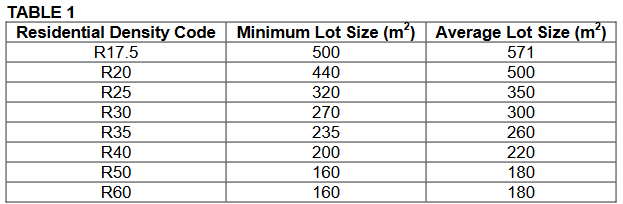
The maximum number of lots permitted for single and grouped dwellings is determined through the zoning of the property. Minimum and average lot sizes are outlined in Table 1 of the Residential Design Codes. Multiple dwellings are determined separately through the plot ratio requirements outlined in Table 4 of the Residential Design Codes, which provide a maximum permittable total floor area rather than a minimum site area per dwelling.
APPLICATIONS and CLEARANCES
Applications for freehold or survey-strata subdivision are made to the Department of Planning, Lands and Heritage. These applications are generally referred to the local authority (City Council), Water Corporation and Western Power for their comment and recommendation during the assessment process.
Subdivision approvals will in most instances have conditions of approval. Typically landowners have three years to address these conditions and seek clearance from the relevant clearing authority to confirm the conditions have been met.
When all clearances are satisfactorily met, final subdivision stage and application to Landgate for titles can be processed.
DENSITY BONUSES
The potential entitlement to a density bonus exists for the construction of certain types of dwellings, such as housing for the elderly or single bedroom units. The potential also exists to obtain approval for construction of ancillary accommodation, often referred to as a ‘granny flat’. All of the density bonuses are subject to Residential Design Codes and local planning policies and generally subject to local authorities development approvals.
Other services that form part of survey and subdivision processes include:
Subdivision Planning and Design
Town Planning
Re-zoning & Scheme Amendments
All Subdivision Applications
Strata and Survey-strata Developments
Licensed Surveying
Boundary Re-peg Surveys
Construction Set-out and As-constructed Plans
Project Management
All of the above is necessary knowledge and understanding that any Designer should take into account when designing grouped dwellings, apartments or other proposed buildings and structures that may form part of land subdivision process.
We have aimed to create a simplified guide to subdivision steps above, but for more information please visit the Department of Planning and Landgate websites.
For a complimentary consultation regarding this area of work, helpful advice for the correct selection of surveyor, or if you require more information regarding your potential subdivision, please get in touch.